白皮书07 · 第1章 · 中文摘要
克里比环境:海岸敏感,钢铁厂厂址与之保持距离
钢铁综合体规划建于克里比港综合工业区的沿海台地上,距港口前沿约3至4公里。区域内最具价值的自然和文化资源均位于较远处,但空气、水、交通和人口流动将其与厂址相连,因此评估必须覆盖整个景观,而不仅限于厂界之内。
本页为本章中文摘要;英文全文附于其后,可展开阅读。
厂址周边是农田与森林镶嵌的景观,小溪流纵横,渔村和农村环绕。海洋国家公园北界距厂址约12公里,洛贝瀑布约18公里,坎波-马安国家公园约29公里;最近的已测绘居民点Boussibelika约3至4公里,Mbodé约4至5公里,Mboro约4至5公里(上述距离均取自全文版附录D表D.1)。根据2009年的公共利益声明(DUP)和2023年的总统令,该区域早已由国家划定为工业港口用地,其中港区约1.5万公顷。克里比属赤道气候,年降雨量约2800至2900毫米,没有真正的旱月,9月和10月每月降雨约500毫米;西南风和南风约占全年时数的72%。2000年以来海岸由缓慢淤积转为后退,2015至2020年平均每年后退约2米,洛贝瀑布附近局部每年后退约32米。由此我们得出五项设计原则:评估整个景观而非厂界;按全年每月均有降雨进行水务设计;远离海岸,不新建自有海岸设施;优先保护尚未测绘的小溪流;先实测、后建模。
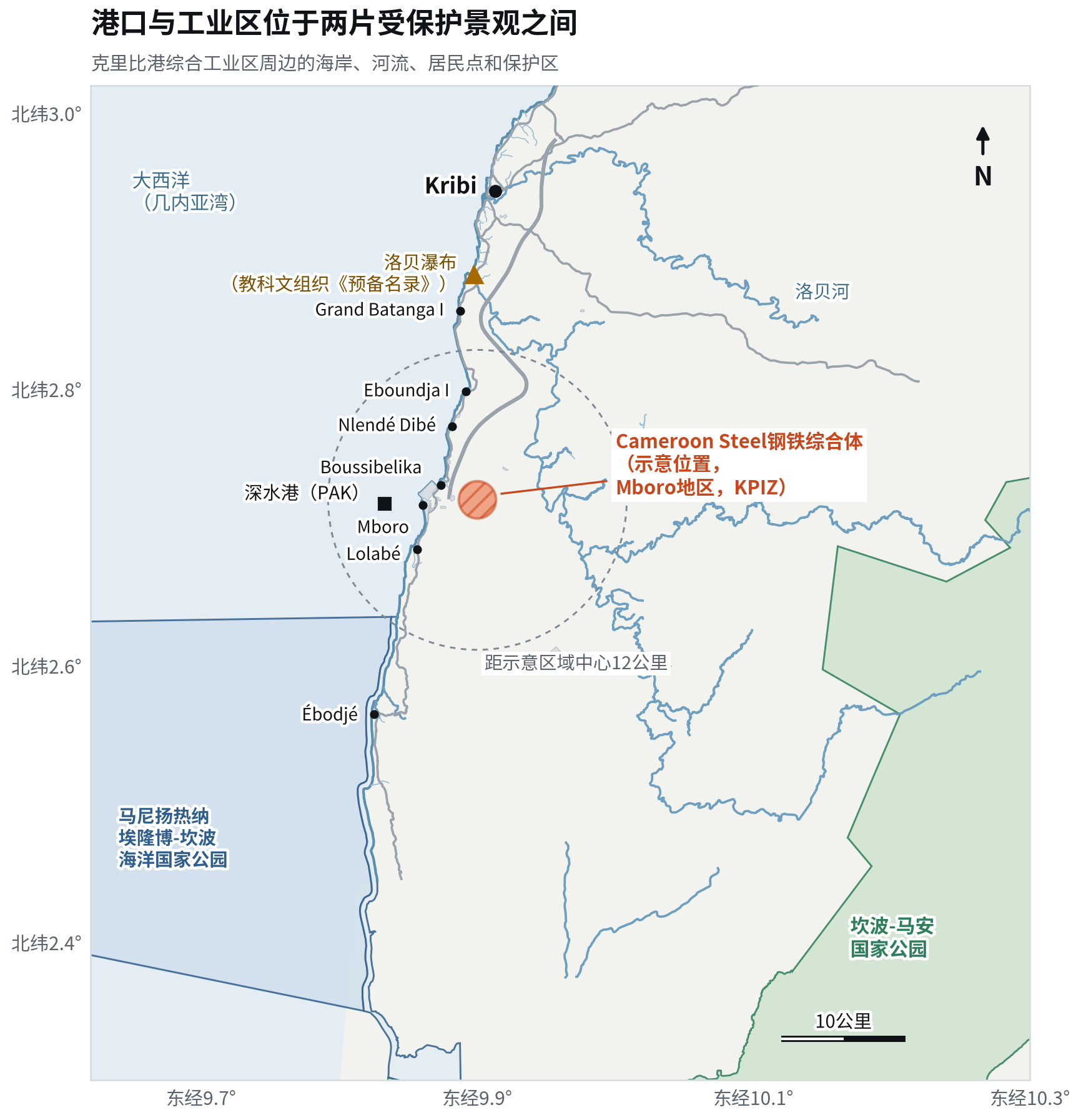
资料来源:OpenStreetMap贡献者(ODbL)[E11];Natural Earth [E12];第2021/4804/PM号法令[B01];第2000/004/PM号法令[B02];教科文组织《预备名录》[B04]。Cameroon Steel分析。
英文全文 12分钟 · 2838词The Kribi setting: a sensitive coast, with the steel site set back from it
The steel complex is planned on the coastal plateau of the Kribi industrial-port zone, about 3 to 4 km inland from the port frontage, in a farm and forest mosaic crossed by small streams and ringed by fishing and farming villages. The region’s most valued natural and cultural assets are farther away: the Manyange na Elombo-Campo Marine National Park begins about 12 km to the south-west, the Chutes de la Lobé lie about 18 km to the north and Campo-Ma’an National Park about 29 km to the east. They are not on the site, but air, water, traffic and people link them to it. The assessment therefore has to cover the whole landscape, not just the fence line, and it has to start from measured local data rather than regional averages.
1.1 A coastal plateau inside a declared industrial-port zone
Cameroon Steel is developing its steel complex at Mboro, inside the Kribi industrial-port zone in the Océan department of the South Region. The Prime Minister, representing the Head of State, laid the foundation stone on 30 December 2024 [X01]. The design capacity is 1 Mtpa, to be built in phases [X02]. The first phase is a melt shop with an electric arc furnace (EAF) whose billets feed mills for reinforcing bar and wire rod or are sold to existing re-rollers [X03]. The site lies in an area that the State has set aside for heavy industry for more than fifteen years. A ministerial order of 6 February 2009 declared the deep-water port of public utility. The port and its industrial hinterland were then developed on land at Mboro, Lolabé and Grand Batanga [H03]. A presidential decree of 23 June 2023 fixed the public port domain at about 15,000 ha, within a larger industrial-port complex of about 26,000 ha [K05][K06].
On 26 February 2026 the Port Autonome de Kribi (PAK) and its partners launched Kribi Port Industrial Zone S.A. (KPIZ). The company’s mandate is to design, finance, develop and operate an integrated industrial zone of about 4,000 ha over 15 years, at a total investment of €795 million [K02][K03]. KPIZ lists "steelmaking linked to mineral exports" among its development clusters [K02]. The African Development Bank (AfDB), the European Union and the International Finance Corporation (IFC) are named as financing partners of the zone [K03][K04]. This has two consequences for a steelworks. First, the land use is already industrial by public decision, so the question is how to build well rather than whether to industrialise a pristine site. Second, the zone’s lenders apply the same international standards discussed in Chapter 3, and they will expect tenants to meet them.
The plateau stands well above the sea. Satellite surface models give elevations of roughly 50 to 120 m across the wider area. Because these models include the forest canopy, true ground levels are probably 20 to 30 m lower in wooded cells; we estimate the ground at about 40 to 100 m above sea level (rounded; to be confirmed by survey) [E17]. The terrain is an undulating lateritic plateau, dissected by small valleys that drain westwards to the sea near the port and eastwards towards tributaries of the Lobé. A topographic survey at sub-metre resolution is one of the first studies we need (Chapter 11), because drainage paths and earthworks decide where stormwater, and any spill, would go.
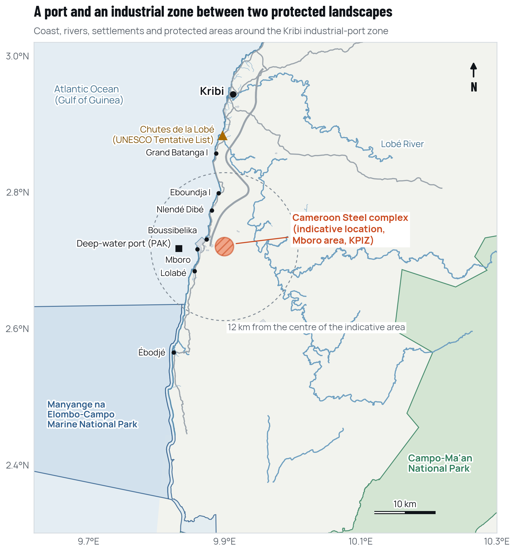
Source: OpenStreetMap contributors (ODbL), Overpass extract base 24 July 2026 [E11]; Natural Earth admin-0 [E12]; Décret 2021/4804/PM [B01]; Décret 2000/004/PM [B02]; UNESCO Tentative List [B04]. Cameroon Steel analysis.
1.2 An equatorial climate with no truly dry month
Kribi is one of the wettest places on Cameroon’s coast outside the Mount Cameroon area. The homogenised Kribi station record for 1937 to 1976 gives a mean annual rainfall of 2,836 mm, with a 95% confidence interval for the mean of 2,719 to 2,953 mm [E01]. Climate normals published by the World Meteorological Organization (WMO) for Kribi, supplied by the national meteorological service, give about 2,900 mm a year for 1981 to 2010 [E09]. A modelled ERA5 series for 1991 to 2020 gives 2,836 mm, with individual years ranging from about 2,200 to 3,400 mm [E04]. We therefore plan on about 2,800 to 2,900 mm a year. We also note two widely circulated figures that should not be used. One, at about 3,000 mm, is in fact a Douala series. The other, at about 1,450 mm, is implausibly low [E01].
The rainfall regime has four seasons, damped by the ocean. Figure 1.2 shows the monthly means. December to February is the main "dry" season, yet each month still brings about 90 to 120 mm. The first rains run from March to June. A short, weak relative dry spell comes in July. The main wet season, in September and October, brings about 500 mm a month [E01]. Mean daily maxima are about 28 to 31.5 °C and mean minima about 22 to 24 °C [E09]. Relative humidity reaches 92 to 96% at night [E01]. These figures matter for four reasons:
- stormwater systems must work every month of the year;
- open stockpiles will generate run-off in every season;
- heat stress is a year-round occupational issue;
- ecological surveys must be scheduled around access in the wettest months.
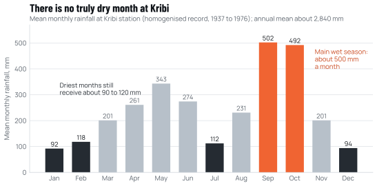
Source: J.-C. Olivry, Monographie du Nyong et des fleuves côtiers, ORSTOM, 1979 [E01]. The monthly means as published sum to about 2,920 mm; the homogenised annual mean is 2,836 mm.
The prevailing winds come from the sea. The port authority describes the predominant wind as south to south-west [E07]. A modelled ERA5 series for 2011 to 2020 gives a mean wind speed of 2.3 m/s. The south-west sector accounts for 44.7% of hours and the south for 27.2% [E04]. By day the onshore sea breeze dominates. At night a south to south-east land-breeze component appears. Squall lines can bring short, violent gusts of about 20 m/s that stations rarely record [E01][E02]. Chapter 4 explains why this pattern is broadly favourable for the coastal villages by day, but needs care at night.
1.3 Rivers, streams and groundwater
Two coastal rivers frame the area. The Lobé drains about 2,300 km² and reaches the sea over the Lobé falls. Its mean flow is 102 m³/s, its median low flow 8.35 m³/s (minimum recorded 3.5 m³/s), and its estimated 100-year flood 565 m³/s [E01]. The Kienké, which reaches the sea at Kribi town, has a mean flow of 49.2 m³/s and a 10-year dry-season low flow of 4.68 m³/s [E01]. The nearest mapped segment of the Lobé’s main channel lies about 4 to 5 km east of the indicative steel site area; other mapped segments of the main stem lie up to about 7 km away [E11].
The water bodies that matter most for the plant are much smaller. The nearest mapped watercourse is the Boussibelika stream, about 2 to 3 km to the west, which drains to the sea near the port [E11]. Small, unnamed streams and seasonal wetlands probably drain the plateau itself, but public maps omit most of them. There are no flow or quality data for any of these streams. They are the probable receiving waters for treated stormwater, so we treat their survey as a critical-path task (Chapter 5).
Groundwater is equally undocumented. The soils are deep, strongly acidic yellow ferrallitic (lateritic) soils, with a weathered mantle that can exceed 15 m over gneiss of the Nyong complex [E01][E02]. Aquifers are expected in the weathered layer and in fractured rock. The nearby Kribi gas power plant draws on boreholes [E15]. We found no published water-table depth, yield or quality for the site area. The aquifer’s vulnerability to spills, and its value to villages that use wells, can only be established by drilling and monitoring.
1.4 A coast already reshaped by the port
The shoreline south of Kribi has changed sharply since the port was built. A peer-reviewed study of satellite and map records found net accretion of about 0.4 m a year between 1973 and 2000. It then found average retreat of 0.9 m a year between 2000 and 2015, and about 2 m a year between 2015 and 2020 [E02]. Local rates are far higher. The study reports retreat of about 32 m a year at the Lobé falls in 2015 to 2020, and 45 to 70 m a year near Lolabé in 2013 to 2017. Updrift of the port’s breakwater, the beach has accreted by more than 15 m a year as the structure traps sand carried by the northward longshore drift [E02]. A 2025 assessment rates 68.3% of the 31.5 km Kribi coast as highly vulnerable and links this to sediment trapping by the breakwater [E03]. Turtle specialists report about 15 m of retreat in places at Ebodjé, inside the marine park [B05].
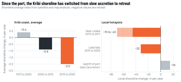
Source: Fendoung, Tchindjang and Hubert-Ferrari, Land 11:1557, 2022 [E02]; Perabi et al., 2025 [E03].
Sea-level rise will add to this pressure. The Intergovernmental Panel on Climate Change (IPCC) projects a likely global mean rise by 2100, relative to 1995 to 2014, of 0.44 to 0.76 m under an intermediate-emissions scenario (SSP2-4.5). Under a very high-emissions scenario (SSP5-8.5) the likely rise is 0.63 to 1.01 m. A rise of about 2 m by 2100 cannot be ruled out as a low-likelihood outcome [E08]. Kribi-specific projections have not yet been obtained.
For the steel complex, this is a matter of where things are placed. The melt shop, mills and stockyards sit on the plateau, tens of metres above the sea, and are not exposed to coastal flooding. Any coastal component would be exposed. That includes a dedicated berth, a seawater intake, an outfall or a conveyor landfall. Such a component would need a shoreline-change analysis and sea-level-rise allowance of its own. Our current planning assumes that raw materials and products move through the port’s existing and planned terminals rather than a dedicated jetty. Under that assumption, the steel complex adds no new coastal structure. We will confirm this in the project description filed with the terms of reference.
1.5 Protected areas and a cultural landscape
Four protected or internationally recognised areas lie within about 60 km (Table 1.1). None is on or adjacent to the site. Their distances are approximate, and every receptor distance quoted in this paper is taken from one reference table (Annex D, Table D.1). We measured them from public geodata (OpenStreetMap and the boundary points published in the creation decrees) from the centre of a generalised indicative area, not from a surveyed boundary, and round them to whole kilometres.
Table 1.1 Protected and internationally recognised areas around the Kribi industrial-port zone
| Area | Legal basis | Size | Approximate distance and bearing | Key values |
|---|---|---|---|---|
| Manyange na Elombo-Campo Marine National Park | Décret 2021/4804/PM, July 2021 [B01] | 110,300 ha plus a 3,400 ha buffer zone | About 12 km, south-west (northern limit) | Turtle nesting beaches at Ebodjé, cetaceans, Ntem estuary mangroves; covers ten villages |
| Chutes de la Lobé | UNESCO Tentative List, ref. 6330, 2018 [B04] | Cultural landscape | About 18 km, north | A river falling directly into the sea; sacred to the Batanga, Mabi and Bagyeli |
| Campo-Ma’an National Park | Décret 2000/004/PM, 6 January 2000 [B02] | 264,064 ha | About 29 km, east | Western lowland gorilla and forest elephant (both Critically Endangered), central chimpanzee (Endangered); 302 bird species recorded [B08][B10][B11] |
| Douala-Edéa National Park | Decree of 2018 converting the former wildlife reserve [B03] | 262,935 ha | About 55 km, north-north-west | Mangroves, lowland forest, African manatee, marine turtles |
Source: creation decrees and UNESCO listing as cited; distances derived by Cameroon Steel from OpenStreetMap (queried 10 October 2026) and decree boundary points [E11][B01]. Press reports quote a distance of 22.9 km from the port to the marine park boundary [B05]; the decree’s boundary points take precedence.
The marine park is the youngest and closest of these areas. It was created in 2021 and its management was appointed in 2023 [E13]. Its buffer zone includes a 300 m strip at sea, a land strip above the high-water line, Lake Pitché and the mouth of the Ntem [B01]. The park covers ten villages. Among them is Ebodjé, a community of about 3,000 people, around 80% of whom work in fishing [B05]. Local monitoring and a port-supported turtle programme have documented olive ridley and leatherback nesting there [B06][B07].
The Chutes de la Lobé are both a natural feature and a cultural one. The UNESCO Tentative List entry describes a cultural landscape where the river falls over cascades directly into the sea. The site is associated with the beliefs and rites of the Batanga, Mabi and Bagyeli peoples [B04]. The falls lie downstream of any discharge to the Lobé basin. This is one reason for our design rule that no process water will be discharged to that basin without a specific study (Chapter 5).
1.6 Forests, farms and fishing villages
The coastal plateau between Kribi and Lolabé lies in the Atlantic coastal equatorial forest belt of Lower Guinea [B08]. Today it is a mosaic of secondary forest, cassava, plantain and cocoyam fallows, small cocoa and oil-palm plots, and older forest along the valleys. The actual vegetation of the steel site area has not yet been mapped. Public building maps show no mapped structures within about 1 km of the indicative area, but those maps are clearly incomplete [E11]. A ground-truthed land-cover map and a census of any users of the land are therefore among the first tasks of the assessment.
The nearest mapped settlements are Boussibelika, about 3 to 4 km to the west-north-west, Mbodé, about 4 to 5 km to the north-west, and Mboro, about 4 to 5 km to the west. Lolabé is about 6 to 7 km to the south-west and the Eboundja villages are farther north along the coast [E11]. The population is diverse:
- Batanga coastal fishing and farming families;
- Mabi lineages;
- Bagyeli (also called Bakola) hunter-gatherer communities, recognised as Indigenous Peoples under international standards;
- migrants from other regions of Cameroon, drawn by the port and the zone [B04][H05][E13].
Chapter 8 sets out what is known about them, and what is not.
The landscape is also changing fast for reasons unrelated to steel. Traffic through the port rose from 7 Mt in 2018 to 12.7 Mt in 2025, according to the port authority [K08]. A press report in 2024 put the population of Kribi at about 90,000, with projections of 300,000 by 2040 [E13]. Other projects are planned or under way in the same coastal strip. They include a mineral terminal, new railways, a cement plant, quarries and an iron ore mine on the Lobé (Chapter 9). Any honest assessment of a steelworks here has to separate its own contribution from these cumulative pressures, and has to contribute to managing them.
1.7 What the setting means for design
- Assess the landscape, not the fence line. The receptors that matter most (the marine park, the Lobé falls, Campo-Ma’an, the coastal villages) are reached through air, water, traffic and people, so the area of influence extends well beyond the site.
- Design for water every month. With about 2,850 mm of rain a year and no dry month, stormwater, not water supply, is the main hydrological design driver.
- Stay off the coast. Keeping all process units on the plateau and using the port’s terminals avoids adding to a shoreline that is already retreating.
- Protect the small streams first. The unmapped streams on the plateau are the most likely receiving waters, and the ones about which least is known.
- Measure before modelling. No measured air, noise, water or ecological data exist for the site area; each must be collected across seasons before impacts are predicted.
These five points run through the rest of this paper. Chapter 2 sets out the national procedure that turns them into permit conditions. Chapter 3 explains the international standards that turn them into lender requirements.
Other sources cited in the English text
- X01Kribi: le Premier ministre, chef du gouvernement est là (foundation stone of the Kribi steel complex). Cameroon Tribune, 30 Dec 2024.cameroon-tribune.cm/article.html/68499/fr.html/details_2
- X02Industrialisation: la voie royale de l’émergence (1 Mtpa capacity). Cameroon Tribune, 2 Jan 2025.cameroon-tribune.cm/article.html/68558/fr.html/details_2
- X03Cameroon Steel reference configuration RC-1 (planning estimate): planned capacities, phases, indicative schedule and benchmark-based estimates, edition of 10 October 2026. Cameroon Steel, 10 Oct 2026.Cited by title and date
- H03Le port de Kribi: force ou menace pour la proposition d’inscription des chutes de la Lobé sur la liste du patrimoine mondial (academic thesis). Memoire Online, 2021.memoireonline.com/12/21/12599/m_Le-port-de-Kribi-Force-ou-menace-pour-…
- K05Le PAK tient enfin son titre foncier (presidential decree of 23 June 2023 on the port domain). Port Autonome de Kribi, 26 Jun 2023.Cited by title and date
- K06Présentation du Port Autonome de Kribi (brochure). Port Autonome de Kribi, Oct 2018.Cited by title and date
- K02Zone industrialo-portuaire de Kribi (KPIZ): jusqu’à +8 points de croissance et 150 000 emplois attendus sur 15 ans. Investir au Cameroun, 4 Mar 2026.investiraucameroun.com/gestion-publique/0403-23163-zone-industrialo-po…
- K03Cameroon launches $860m Kribi industrial zone to process raw materials locally; PAK, AGL, Arise IIP and Belmont launch €795m Kribi Port Industrial Zone. Ecofin Agency; Business in Cameroon, 27 Feb 2026.ecofinagency.com/news/2702-53326-cameroon-launches-860m-kribi-industri…
- K04Cameroon: African Development Bank Group supports development of integrated industrial zone at the Port of Kribi. African Development Bank (via AllAfrica), 2 Mar 2026.allafrica.com/stories/202603100682.html
- E17SRTM 30 m digital surface model, accessed through the OpenTopoData API. NASA; OpenTopoData.opentopodata.org/datasets/srtm/
- E01Monographie du Nyong et des fleuves côtiers, tome 1 (J.-C. Olivry). ORSTOM (now IRD), Jul 1979.horizon.documentation.ird.fr/exl-doc/pleins_textes/divers11-03/01948.p…
- E09World Weather Information Service: Kribi, climatological information (rainfall 1981 to 2010; data from the Direction de la Météorologie Nationale). World Meteorological Organization.worldweather.wmo.int/en/city.html?cityId=1517
- E04ERA5 hourly reanalysis (precipitation, wind, temperature), accessed through the Open-Meteo historical weather API. ECMWF; Open-Meteo.open-meteo.com/en/docs/historical-weather-api
- E07Guide du Port de Kribi. Port Autonome de Kribi, Aug 2020.Cited by title and date
- E02Weakening of coastlines and coastal erosion in the Gulf of Guinea: the case of the Kribi coastline in Cameroon (Fendoung, Tchindjang and Hubert-Ferrari), Land 11:1557. MDPI, 2022.doi.org/10.3390/land11091557
- E15Environmental and Social Review Summary 25978, Kribi (gas-fired power plant). International Finance Corporation, 2010.disclosures.ifc.org/project-detail/ESRS/25978/kribi
- E03Geomatics-based assessment of coastal vulnerability in Kribi (Perabi et al.), Urban Resilience and Sustainability 3(4). AIMS Press, Nov 2025.aimspress.com/aimspress-data/urs/2025/4/PDF/urs-03-04-012.pdf
- B05Unchecked development threatens Cameroon’s Manyange Na Elombo-Campo marine park (L. Bongben). Global Voices (secondary source), 22 Nov 2025.globalvoices.org/2025/11/22/unchecked-development-threatens-cameroons-…
- E08Climate Change 2021: The Physical Science Basis, Summary for Policymakers. Intergovernmental Panel on Climate Change, 2021.ipcc.ch/report/ar6/wg1/downloads/report/IPCC_AR6_WGI_SPM.pdf
- B08Campo Ma’an National Park, Tropical Important Plant Areas factsheet CMNTIPA025 (B. Murphy and J. M. Onana). Royal Botanic Gardens, Kew.tipas.kew.org/site/campo-maan-national-park/
- B10IUCN Red List assessments (version 2026-1): Gobush et al. 2021, Loxodonta cyclotis , e.T181007989A204404464; Maisels et al. 2018, Gorilla gorilla gorilla , e.T9406A136251508; Maisels et al. 2016, Pan troglodytes troglodytes , e.T15936A102332276; Pietersen et al. 2019, Phataginus tricuspis , e.T12767A123586469; Nixon et al. 2019, Smutsia gigantea , e.T12762A123584478; BirdLife International 2018, Psittacus erithacus , e.T22724813A129879439; Keith Diagne 2015, Trichechus senegalensis , e.T22104A97168578; Wallace et al. 2013, Dermochelys coriacea , e.T6494A43526147; Abreu-Grobois and Plotkin 2008, Lepidochelys olivacea , e.T11534A3292503; Mortimer and Donnelly 2008, Eretmochelys imbricata , e.T8005A12881238; Wallace and Broderick 2025, Chelonia mydas , e.T4615A285108125. International Union for Conservation of Nature, 2008 to 2025; accessed 10 Oct 2026.iucnredlist.org
- B11Parc national de Campo Ma’an (Tentative List, ref. 6312). UNESCO World Heritage Centre, 2 Feb 2018.whc.unesco.org/en/tentativelists/6312/
- B03Décret portant mutation de la Réserve de Faune de Douala-Edéa en Parc National. Services du Premier Ministre, 2018.spm.gov.cm/site/sites/default/files/mutation%20de%20la%20reserve%20de%…
- E13As a megaport rises in Cameroon, a delicate coastal ecosystem ebbs (E. Toto). Mongabay (secondary source), 5 Apr 2024.news.mongabay.com/2024/04/as-a-megaport-rises-in-cameroon-a-delicate-c…
- B06Beach patrols for marine turtle nesting stock estimation in the Atlantic coastline of Ebodje, Cameroon (A. H. Nibam). Rufford Foundation, 2018.rufford.org/projects/abi-henry-nibam/beach-patrols-for-marine-turtle-n…
- B07Protecting biodiversity: the Port Authority of Kribi supports turtle conservation in Ebodje. Port Autonome de Kribi, 16 Mar 2023.Cited by title and date
- H05Bagyeli/Bakola documentation project: geography. DoBeS programme (Documentation of Endangered Languages), Max Planck Institute for Psycholinguistics.dobes.mpi.nl/?p=984
- K08Port de Kribi: la performance au service de la Nation (op-ed by the Director General of the port). Port Autonome de Kribi, 21 Apr 2026.Cited by title and date
本章引用的资料来源
方括号内的标记对应以下来源(按原文语言列出),完整列表见附录。 完整来源列表
- E11OpenStreetMap data, Overpass API extract for the Kribi area (coastline, watercourses, roads, settlements, landuse, protected areas). OpenStreetMap contributors (ODbL),数据基准日2026年7月24日;查询于2026年10月10日.openstreetmap.org
- E12Natural Earth 1:50m cultural vectors, admin-0 countries. Natural Earth,第5版.naturalearthdata.com
- B01Décret n° 2021/4804/PM portant création du Parc National Marin Manyange na Elombo-Campo. Prime Minister (FAOLEX copy),2021年7月9日.faolex.fao.org/docs/pdf/cmr220623.pdf
- B02Décret n° 2000/004/PM portant création du Parc National de Campo-Ma’an. Prime Minister (FAOLEX copy),2000年1月6日.faolex.fao.org/docs/pdf/cmr26727.pdf
- B04Le paysage culturel des chutes de la Lobé (Tentative List, ref. 6330). UNESCO World Heritage Centre,2018年.whc.unesco.org/fr/listesindicatives/6330/
引用本章
Cameroon Steel(2026)。在克里比负责任地建设:满足四项条件,钢铁厂即可达到国际标准(中文摘要版)。白皮书07,第1章:克里比环境:海岸敏感,钢铁厂厂址与之保持距离。CS-WP-07。https://www.cameroon-steel.com/zh/library/responsible-kribi/kribi-setting/
来源