白皮书07 · 第11章 · 中文摘要
证据缺口:尚未掌握的信息及其获取方式
本文基于案头研究,足以提出正确的问题和承诺,但不足以预测影响。厂址区域没有任何空气、噪声、水、土壤或生态实测数据,周边居民没有人口普查数据,若干重要文件由公共机构持有且尚未公开。
本页为本章中文摘要;英文全文附于其后,可展开阅读。
缺口分为四类:须在厂址跨季节实测的物理基线;须与社区共同在现场开展的生物和社会调查;公共机构及其他项目持有的文件和数据;须由工程设计解答的技术和市场问题。主要缺口及弥补方式包括:土地覆盖和栖息地制图(第0至3个月);现场气象和空气质量监测(第0至12个月);6至8个点位、四轮次的地表水和小溪流调查(第1至12个月);两季动植物调查和关键栖息地评估(第1至14个月);人口普查、至少400户的生计调查和土地档案审查(第1至6个月);与巴吉耶利人组织合作的原住民专项筛查(第1至10个月);以及向PAK、KPIZ和环境部正式申请调阅工业区战略环境评估和2009至2010年的土地档案,并查明工业区取水厂的水源(第0至3个月)。英文版和法文版全文的缺口表列明了每项工作的负责方和时间。基线的目的在于根据证据修改项目:若发现狭域特有鱼类,总平面布置将予避让;若发现土地现有使用者,将首先通过布置调整避免搬迁;若空气环境容量低于预期,将在申请许可前加强控制措施;若触发FPIC,相关活动将等待其结果。基线数据将在采集过程中按季度公布。
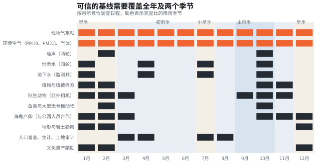
资料来源:Cameroon Steel分析;季节划分依据Olivry(1979年)[E01];海龟产卵季节待与海洋公园管理机构确认。
英文全文 7分钟 · 1498词Evidence gaps: what is not yet known, and how it will be found out
This paper rests on desk research: public laws and standards, published science, reanalysis data, public maps and the press. That is enough to set the right questions and the right commitments. It is not enough to predict impacts. No measured air, noise, water, soil or ecological data exist for the steel site area. No census exists of the people who live around it. Several important documents are held by public bodies and have not been published. This chapter lists the main gaps, explains why each matters and states how and when it will be closed. Closing them is the first phase of the work described in Chapter 10.
11.1 Why the gaps matter
Each gap stands between a general statement and a specific prediction. Modelled background fine particles at Kribi already exceed the WHO guideline (Chapter 4). But the margin left for the project depends on what a year of on-site monitoring shows. The small streams on the plateau may hold restricted-range fishes (Chapter 7), and only a survey in high and low water can tell. The land may have been fully released by its former users, or it may still be farmed (Chapter 8), and only a census and a legacy review can establish which. Until these questions are answered, any confident prediction would be guesswork.
The gaps fall into four groups:
- physical baselines that must be measured on site across seasons;
- biological and social surveys that must be done in the field, with communities;
- documents and data held by public authorities and other projects;
- technical and market questions that the engineering design must answer.
11.2 The gaps and how they will be closed
Table 11.1 Main evidence gaps and how they will be resolved
| Gap | Why it matters | How it will be resolved | Who | When (months from mobilisation) |
|---|---|---|---|---|
| Land cover and habitat on and around the site | Distinguishes modified from natural habitat; fixes the footprint and the buffers | Very-high-resolution imagery and satellite classification, ground-truthed in the field | ESIA consultant (approved firm); remote-sensing specialist | 0 to 3 |
| Topography and drainage | Drives earthworks, stormwater design and spill pathways | Drone or airborne survey to a sub-metre terrain model; catchment delineation | Cameroon Steel, survey contractor | 0 to 3 (dry season preferred) |
| On-site meteorology | Drives the dispersion model for every air prediction | Automatic weather station with a 10 m mast, at least 12 months | ESIA consultant | 0 to 12 |
| Ambient air quality and dust deposition | Confirms whether the airshed is degraded; sets the project’s margin | Reference-equivalent PM10 and PM2.5 monitors, passive tubes for gases, deposition gauges with metal analysis at 6 to 10 sites | ESIA consultant; accredited laboratory | 0 to 12 |
| Noise | No measured data at any receptor | 24 to 72 hour measurements at 6 to 8 receptors, dry and wet seasons | ESIA consultant | 1 to 10 |
| Short-duration rainfall intensities | Needed to size drains and basins | Pluviograph records from the national meteorological service; on-site rain gauge | ESIA consultant; national meteorological service | 0 to 12 |
| Surface water and the small streams | Probable receiving waters; possible restricted-range fishes | Gauging and sampling at 6 to 8 points in four campaigns; sediment; fish and invertebrate surveys | ESIA consultant; accredited laboratory; ichthyologist | 1 to 12 |
| Groundwater | Supply option and pollution pathway; village wells | At least 6 piezometers, pumping tests, quarterly chemistry | Hydrogeologist (ESIA team) | 2 to 12 |
| Soil quality, including dioxin baseline | Reference against which any future deposition is measured | Grid sampling before construction, accredited laboratory | ESIA consultant; accredited laboratory | 1 to 4 |
| Flora, fauna and critical habitat | Confirms or rules out critical habitat; drives the biodiversity action plan | Two-season surveys; camera traps; critical habitat assessment with an IBAT screening | Specialist ecologists (ESIA team) | 1 to 14 |
| Sea-turtle nesting | Landscape-level indicator and possible contribution | Data sharing and joint patrols with the marine park authority and the Ebodjé community; nesting season to be confirmed | Cameroon Steel with the marine park authority and the Ebodjé community | One nesting season |
| Census, livelihoods and land legacy | Identifies users of the land and gaps from 2009 to 2010 | Census and asset inventory; household survey of at least 400 households; review of the 2009 and 2010 records | ESIA social team; land administration and PAK for the records | 1 to 6 |
| Indigenous Peoples | Determines whether FPIC is triggered | Specialised anthropological screening with Bagyeli organisations; customary-use mapping | Specialist anthropologist with Bagyeli organisations | 1 to 10 |
| Cultural heritage | Sacred sites, graves, archaeology | Archaeological walkover; mapping with chiefs and elders; chance-finds procedure | Archaeologist; chiefs and elders | 1 to 4 |
| Community health | Baseline for influx management | District health records; key-informant interviews; rapid health impact assessment | ESIA consultant; district health services | 2 to 6 |
| Traffic | Baseline for road safety | Classified counts on the N7, motorway and port gates; road safety audit | ESIA consultant | 2 and 8 (two campaigns) |
| Documents held by others | Avoids duplication; tiers the assessment | Formal requests to PAK and KPIZ (port assessments, any zone strategic assessment, land files, utility plans), MINEPDED, and other projects (rail, mining, gas plant monitoring) | Cameroon Steel (formal requests) | 0 to 6 |
| National norms | Confirms whether national limits exist that are stricter than international values | Request to MINEPDED and the national standards body for the 2008 norms and any steel-sector order | Cameroon Steel (request to MINEPDED and ANOR) | 0 to 3 |
| Utilities and shared facilities | Water supply, wastewater, hazardous waste, grid connection | Data requests and design coordination with PAK, KPIZ and the power utilities | Cameroon Steel engineering, with PAK, KPIZ and the utilities | 0 to 9 |
| Source of the zone’s water intake | A port-platform intake on the Lobé would make our supply an indirect abstraction from it | Request to PAK and KPIZ for the intake design and its abstraction authorisation; specific study if the Lobé is the source | Cameroon Steel, with PAK, KPIZ and MINEE | 0 to 3 |
| Slag market and EAF dust outlet | Turn residues into products; secure the hazardous route | Market study for aggregates; tenders for zinc recovery; secure-cell feasibility | Cameroon Steel | 3 to 18 |
Source: Cameroon Steel analysis of the desk baseline; methods follow IFC guidance [G01][G02][G03][G04] and Décret 2013/0171/PM [L02].
11.3 The calendar is set by the seasons
Several surveys must catch particular conditions: low and high river flow, the dry-season window for earthworks and archaeology, the main wet season for drainage, and the turtle nesting season on the beaches. Figure 11.1 lays out an indicative calendar by month against Kribi’s rainfall seasons. Its message is simple. A credible baseline needs a full year and both seasons. Starting it as early as possible is the single most effective way to shorten the overall programme without cutting corners.
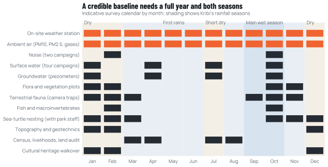
Source: Cameroon Steel analysis; seasons from Olivry, 1979 [E01]; turtle nesting season to be confirmed with the marine park authority.
11.4 Questions we cannot answer alone
Some gaps can only be closed by others, or jointly with them.
The zone’s strategic assessment. The 2016 order requires a strategic environmental assessment for industrial zones and industrial-port complexes [L03]. If one exists for Kribi, our assessment should build on it. If none exists, we will support its preparation (Chapter 9).
The land records. The files of the 2009 declaration of public utility and the 2010 compensation decree are held by the land administration and the port authority. We will ask for access as a first step of the land legacy review.
Existing baselines. The port, the gas power plant, the motorway and the rail and mining projects have each produced environmental studies and, in some cases, years of monitoring. Shared access would improve every project’s assessment, including ours, and would reduce the burden on communities who are asked the same questions repeatedly.
Status of species. The global statuses in Chapter 7 were checked on the IUCN Red List (version 2026-1) for this edition [B10]; they will be checked again when the assessment is filed, because statuses change. Key Biodiversity Area and Important Bird Area designations for the area of influence need confirming through IBAT, which requires a subscription. We will include it in the assessment budget.
11.5 What we will do with what we learn
The purpose of the baseline is to change the project where the evidence requires it. If the surveys find a stream with a restricted-range fish, the layout will move away from it. If the census finds current users of the land, we will try to avoid displacing them through the layout before we plan compensation. If the air monitoring shows less headroom than expected, the controls will be strengthened before the permit is sought. If the Indigenous Peoples screening triggers FPIC, the affecting activities will wait for the outcome. We will publish the baseline data quarterly as they are collected (Chapter 10), so that others can check our reasoning as well as our conclusions.
Other sources cited in the English text
- G01Performance Standards on Environmental and Social Sustainability. International Finance Corporation, 1 Jan 2012.ifc.org/en/insights-reports/2012/ifc-performance-standards
- G02Guidance Note 6: Biodiversity Conservation and Sustainable Management of Living Natural Resources (updated). International Finance Corporation, 27 Jun 2019.ifc.org/en/insights-reports/2012/ifc-performance-standards
- G03Environmental, Health, and Safety Guidelines for Integrated Steel Mills. IFC / World Bank Group, 30 Apr 2007.ifc.org/content/dam/ifc/doc/2000/2007-integrated-steel-mills-ehs-guide…
- G04Environmental, Health, and Safety (General) Guidelines. IFC / World Bank Group, 30 Apr 2007.ifc.org/content/dam/ifc/doc/2000/2007-general-ehs-guidelines-en.pdf
- L02Décret n° 2013/0171/PM fixant les modalités de réalisation des études d’impact environnemental et social. Prime Minister (FAOLEX copy), 14 Feb 2013.faolex.fao.org/docs/pdf/cmr179401.pdf
- L03Arrêté n° 00001/MINEPDED fixant les catégories d’opérations soumises à une évaluation environnementale stratégique ou à une étude d’impact environnemental et social. MINEPDED (FAOLEX copy), 8 Feb 2016.faolex.fao.org/docs/pdf/cmr172054.pdf
- B10IUCN Red List assessments (version 2026-1): Gobush et al. 2021, Loxodonta cyclotis , e.T181007989A204404464; Maisels et al. 2018, Gorilla gorilla gorilla , e.T9406A136251508; Maisels et al. 2016, Pan troglodytes troglodytes , e.T15936A102332276; Pietersen et al. 2019, Phataginus tricuspis , e.T12767A123586469; Nixon et al. 2019, Smutsia gigantea , e.T12762A123584478; BirdLife International 2018, Psittacus erithacus , e.T22724813A129879439; Keith Diagne 2015, Trichechus senegalensis , e.T22104A97168578; Wallace et al. 2013, Dermochelys coriacea , e.T6494A43526147; Abreu-Grobois and Plotkin 2008, Lepidochelys olivacea , e.T11534A3292503; Mortimer and Donnelly 2008, Eretmochelys imbricata , e.T8005A12881238; Wallace and Broderick 2025, Chelonia mydas , e.T4615A285108125. International Union for Conservation of Nature, 2008 to 2025; accessed 10 Oct 2026.iucnredlist.org
本章引用的资料来源
方括号内的标记对应以下来源(按原文语言列出),完整列表见附录。 完整来源列表
- E01Monographie du Nyong et des fleuves côtiers, tome 1 (J.-C. Olivry). ORSTOM (now IRD),1979年7月.horizon.documentation.ird.fr/exl-doc/pleins_textes/divers11-03/01948.p…
引用本章
Cameroon Steel(2026)。在克里比负责任地建设:满足四项条件,钢铁厂即可达到国际标准(中文摘要版)。白皮书07,第11章:证据缺口:尚未掌握的信息及其获取方式。CS-WP-07。https://www.cameroon-steel.com/zh/library/responsible-kribi/evidence-gaps/
来源